
Here are directions to Points Unknown:
Highway 61 is the only highway along the north shore of Minnesota and the Arrowhead Region. Whether coming from Canada or other portions of Minnesota, this is the highway you will take to Hovland which is where Points Unknown is located.
Once in Hovland, take the Arrowhead Trail (AKA 16) NORTH. It only goes in one direction.
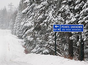
You will go up the Arrowhead Trail roughly 7 miles. At this point, you will see our blue Points Unknown highway sign indicating the turn onto Irish Creek Road. When looking for Irish Creek Road you will not find a typical street sign but a brown forest road sign, unless it is covered in snow, that is on the left hand side of the road and already into the turn. Take a left on Irish Creek Road and go 4/10ths of a mile.
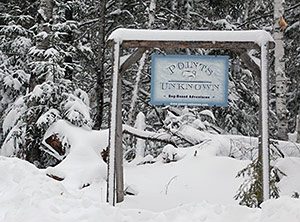
We are at 82 Irish Creek Road. A Points Unknown sign will be at the end of the driveway. You’re here!
ONLY use these directions.
Most satellite navigation systems and even google maps will take you on a wild goose chase and send you on roads that no longer exist. We are “Points Unknown” after all. For the adventurous who insist on trying, our grid location is lat 47.93 x lon -89.98. Click here to map us.
There is NO cell coverage after Grand Marais so please give us a call when leaving Grand Marais, if coming from that direction, so we know when to expect you. If need be, there is a phone at the Chicago Bay Marketplace in Hovland. Call us from there if you encounter any issues. 218.370.0283 or email us at: linda@points-unknown.com.
We’re looking forward to hosting you on this adventure and we’ll see you soon!